OP2B Regeneration Map: Helping business coalitions make Regeneration Efforts Visible Across Europe

CLIENT
PROJECT
One Planet Business for Biodiversity (OP2B) Mapping
LOCATION
SOLUTIONS
explorer.land – customization – embedded map
THE CLIENT
One Planet Business for Biodiversity, hosted by World Business Council for Sustainable Development
The World Business Council for Sustainable Development (WBCSD) is a global, CEO-led organization of over 200 leading businesses working to accelerate the transition to a more sustainable world.
Hosted by WBCSD, One Planet Business for Biodiversity, or OP2B, is an international, cross-sectoral, action-oriented business coalition focused on biodiversity and agriculture.
OP2B works to support the transformation of agriculture so that it becomes profitable for farming communities while regenerating natural capital, rather than depleting it. Its work focuses on scaling regenerative agriculture, enhancing cultivated biodiversity, and protecting high-value ecosystems.
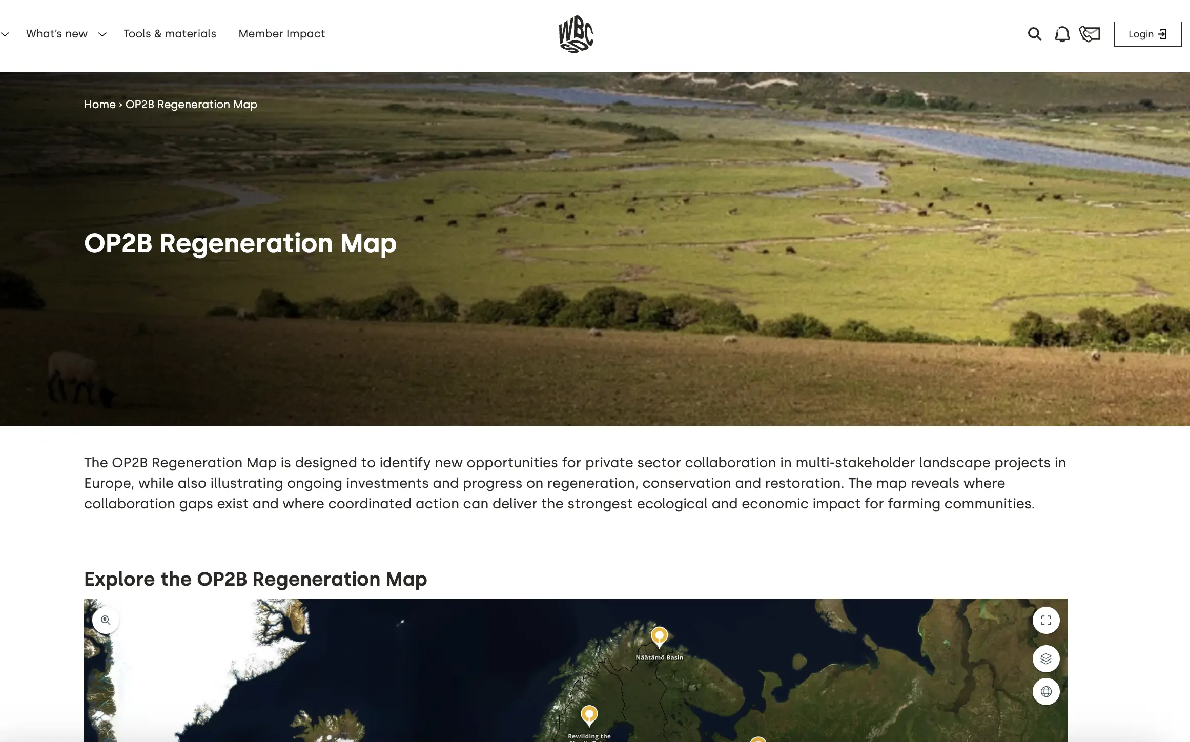
As part of this mission, OP2B developed the OP2B Regeneration Map: an interactive map designed to show ongoing investments and progress on regeneration, conservation, restoration, and nature-based solutions across Europe. The map aims to identify new opportunities for private sector collaboration in multi-stakeholder landscape projects.
The map was developed by OP2B. OP2B is not directly involved in the individual projects aggregated through it. OpenForests supported the development of the map as the technical partner and hosts it through the explorer.land infrastructure.
THE CHALLENGE
Turning scattered regeneration efforts into a shared overview
Across Europe, many initiatives are already working on regenerative agriculture, conservation, restoration, and nature-based solutions. Some focus on productive agricultural land. Others focus on non-productive land, such as rivers, wetlands, forests, and wider ecosystem restoration.
But information about these initiatives is often scattered across project websites, sustainability reports, press releases, databases, and local partner networks.
For OP2B, this fragmentation made it harder to answer important questions:
-> Where are regeneration initiatives already active?
-> Which landscapes are receiving investment and support?
-> Where are the collaboration gaps?
-> Which regions show opportunities for business engagement?
-> How can companies and financiers find relevant landscape-scale opportunities?
-> How can project implementers and farmer organisations become more visible to potential partners?
The challenge was not only to display projects on a map. It was to create a structured, filterable, and decision-useful overview that could support transparent communication, investment exploration, and coordinated action.
OUR APPROACH
Building the OP2B Regeneration Map
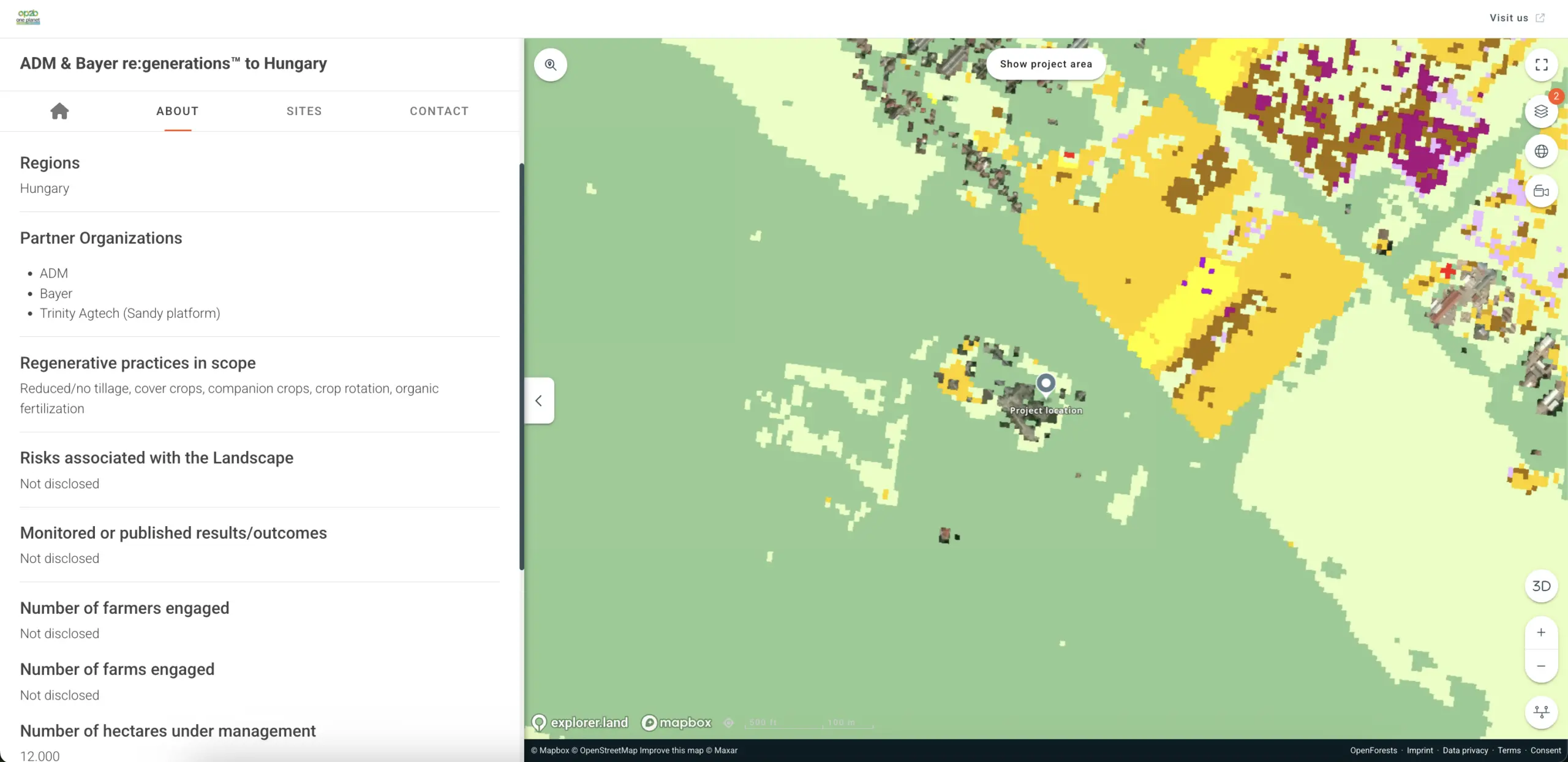
OpenForests helped design, build, and host the OP2B Regeneration Map, using explorer.land as the technical foundation.
The map brings together more than 160 initiatives across Europe, including regenerative agriculture projects, conservation and restoration projects, and nature-based solutions such as agroforestry, river and wetland management, forest diversification, ecosystem-based water management, and landscape management.
The result is an interactive map that helps users explore:
-> where initiatives are located
-> what types of practices are being implemented
-> which partners are involved
-> which goods are sourced within projects
-> what scale the projects operate at
-> which investment models are used
-> where future collaboration may be possible.
01
Structuring project information
One of OpenForests’ key contributions was turning diverse, unstandardized project information into a consistent dataset.
This included structuring information such as project location and area, partners, sponsors, goods sourced within the project, regenerative practices, monitored outcomes, implementation status, investment approaches, and value creation models.
This structure allows users to compare and explore initiatives across different countries, landscapes, and agroecological contexts.
02
Creating a curated and filtrable overview
The OP2B Regeneration Map includes a curated dataset of over 130 regenerative agriculture initiatives and around 30 conservation, restoration, and nature-based solution projects across Europe.
OpenForests helped turn this project inventory into an interactive experience that is easier to navigate, understand, and use. Users can explore initiatives through filters such as goods, size, activity type, and project status.
This makes the map useful for different audiences, including companies, financial institutions, project implementers, farmer organizations, and policymakers.

03
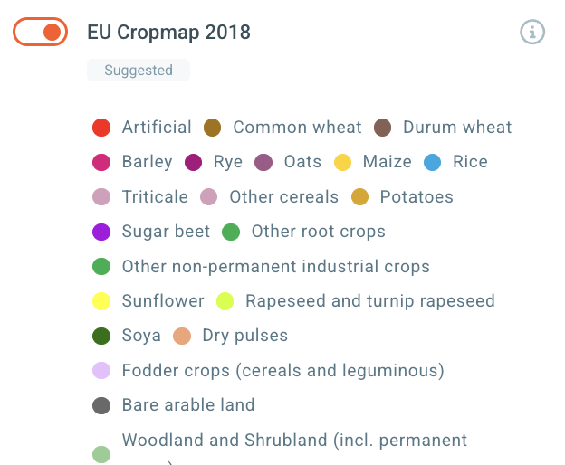
Adding thematic layers for landscape context
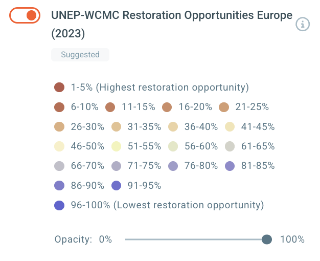
Project locations alone do not tell the full story. To help users understand initiatives in their wider agroecological contexts, OpenForests integrated thematic layers that highlight characteristics, risks, and restoration potential across different regions.
These thematic layers help users move from the simple question “Where are initiatives located?” to more strategic questions: What kind of landscape is this initiative part of? What risks and opportunities exist in this region? Where could collaboration create additional value? Where should further screening or on-the-ground validation take place?
04
Embedding the map into WBCSD’s digital ecosystem
OpenForests also ensured that the map could be embedded directly into the WBCSD website.
This allows the OP2B Regeneration Map to live within WBCSD’s own communication environment while relying on OpenForests’ infrastructure, hosting, and technical support in the background.
THE RESULTS
A shared map to support transparency, collaboration, and landscape-scale opportunities
The OP2B Regeneration Map gives OP2B and its users a clearer view of regeneration, conservation, restoration, and nature-based solution initiatives across Europe.
It helps make visible:
- where initiatives are already active,
- what types of practices are being implemented,
- which partners and investment models are involved,
- where collaboration gaps exist,
- and where coordinated action could support stronger ecological and economic outcomes.
For OP2B, the map supports transparent communication and helps illustrate progress.
For companies and financial institutions, it helps reveal landscape-scale opportunities.
For project implementers and farmer organizations, it can increase visibility and create new pathways for collaboration and co-financing.
For OpenForests, the project shows how interactive maps and structured project data can support complex nature, agriculture, and biodiversity initiatives.
“Our vision for this map was to tackle the fragmentation of regeneration investment by making existing projects visible and easy to find, to enable collaboration at scale across Europe. Working with OpenForests helped us turn our vision into a practical tool that our business members, our partners, and other stakeholders can use and benefit from. ”
Martina Asquini, Senior Associate, Agriculture & Food and OP2B, WBCSD
REPLICATION
A model for other regenerative agriculture and nature coalitions
The OP2B Regeneration Map offers a useful model for other coalitions and organizations working across complex landscapes.
Many nature, agriculture, and biodiversity initiatives face the same challenge: they have projects, partners, and data, but no shared overview that helps people understand the full picture.
A well-designed interactive map can help bring that picture together.
It can support:
This approach can be adapted for regenerative agriculture coalitions, restoration portfolios, conservation finance initiatives, corporate nature strategies, biodiversity programmes, and public-private landscape partnerships.
For OpenForests, this is exactly where our work creates value: helping organizations turn fragmented information into practical tools for coordination, trust, and action.